I am still a ways from the big trip but I am starting to map out a tentative course for my circumnavigation, does anyone have an idea where I can find info on currents, tradewinds & such? I'd rather map out an efficient route, I'll be leaving from the Caribbean and am up in the air about going east or west.
Thanks
Current & wind info?

Re: Current & wind info?
Oh, I just noticed something you wrote so let me add a PS at the beginning:
Not that it's impossible to circumnavigate east, because it can be done, but in general, if you plan to cruise in the non-extreme latitudes, a westabout circumnavigation is the easier one. By easier, I mean that you are more "going with the flow" of nature. You still have to plan your seasons, of course, and that's not to say that every day will be easy :)
Also, going east in the eastern Caribbean (such as from The Bahamas eastward) can be a trial. Again, it can be done with attention to detail, but you would definitely be going "against the grain."
Okay, back to my original response
*****************
1) Routes overviews
I can recommend Jimmy Cornell's "World Cruising Routes" book. It gives an overview of the routes possible, and then tells what's the best season, what you are avoiding by going then, and etc.

Cornell also has a website at http://www.noonsite.com, so that may be a place to take a look (I haven't checked it out recently).
In the same vein, but reportedly even better, is Admiralty's Ocean Passages for the World. I have not used it, because I already had the Cornell book and Ocean Passages is a bit expensive (for something somewhat duplicating what I already had).

2) Pilot charts
Pilot charts are really useful, and I think you can download them for free now.
Check here, for one possibility:
http://www.nga.mil/portal/site/maritime ... d73927a759
This is not a government site, but it looks nice and manageable, and you can download pilot charts:
http://www.offshoreblue.com/navigation/pilot-charts.php
I have a paper booklet of them that is about the size of a chart book (say about 18'' x 30"). They show historical data for winds, waves, storms (and much, much more) for thousands of quadrants of the oceans for each month of the year. The data has been collected over a very long period of time, and is presented in a nifty little rosette graphic that gives you a ton of info in a quick, efficient visual.
A close up of the graphic:

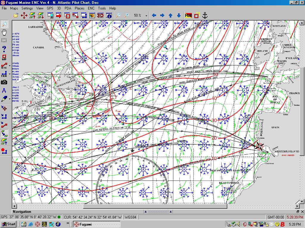
An image from an electronic pilot chart:
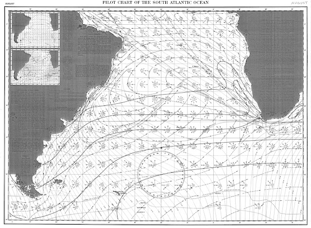
Here is a paper one for comparison:
3) Sailing Directions/Coast Pilots
Another useful tool (although well beneath the former, in my opinion) is the Sailing Directions publications (which I think are called Coast Pilots in the US; mine were Canadian). These give mostly information for bigger ships (in terms of advising about anchorages, etc.) but do have useful overview information on weather patterns and etc. I think these may now be available for free download as well.
4) Regular old charts
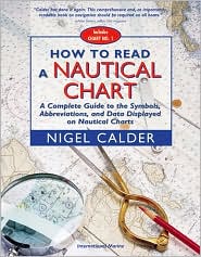
If you haven't used charts a lot (I'm sorry, I can't remember how long you've been boating), you might like Nigel Calder's guide to reading charts. There is so much information on them, that it's sometimes easy to miss how much detail they do give.
Rachel
Not that it's impossible to circumnavigate east, because it can be done, but in general, if you plan to cruise in the non-extreme latitudes, a westabout circumnavigation is the easier one. By easier, I mean that you are more "going with the flow" of nature. You still have to plan your seasons, of course, and that's not to say that every day will be easy :)
Also, going east in the eastern Caribbean (such as from The Bahamas eastward) can be a trial. Again, it can be done with attention to detail, but you would definitely be going "against the grain."
Okay, back to my original response
*****************
1) Routes overviews
I can recommend Jimmy Cornell's "World Cruising Routes" book. It gives an overview of the routes possible, and then tells what's the best season, what you are avoiding by going then, and etc.
Cornell also has a website at http://www.noonsite.com, so that may be a place to take a look (I haven't checked it out recently).
In the same vein, but reportedly even better, is Admiralty's Ocean Passages for the World. I have not used it, because I already had the Cornell book and Ocean Passages is a bit expensive (for something somewhat duplicating what I already had).
2) Pilot charts
Pilot charts are really useful, and I think you can download them for free now.
Check here, for one possibility:
http://www.nga.mil/portal/site/maritime ... d73927a759
This is not a government site, but it looks nice and manageable, and you can download pilot charts:
http://www.offshoreblue.com/navigation/pilot-charts.php
I have a paper booklet of them that is about the size of a chart book (say about 18'' x 30"). They show historical data for winds, waves, storms (and much, much more) for thousands of quadrants of the oceans for each month of the year. The data has been collected over a very long period of time, and is presented in a nifty little rosette graphic that gives you a ton of info in a quick, efficient visual.
A close up of the graphic:
An image from an electronic pilot chart:
Here is a paper one for comparison:
3) Sailing Directions/Coast Pilots
Another useful tool (although well beneath the former, in my opinion) is the Sailing Directions publications (which I think are called Coast Pilots in the US; mine were Canadian). These give mostly information for bigger ships (in terms of advising about anchorages, etc.) but do have useful overview information on weather patterns and etc. I think these may now be available for free download as well.
4) Regular old charts
If you haven't used charts a lot (I'm sorry, I can't remember how long you've been boating), you might like Nigel Calder's guide to reading charts. There is so much information on them, that it's sometimes easy to miss how much detail they do give.
Rachel
-
Gordon
- Bottom Paint Application Technician
- Posts: 22
- Joined: Sun Apr 19, 2009 9:16 am
- Boat Name: Amnesty
- Boat Type: 45' custom Roberts design
- Location: Buzzards Bay, Ma.
- Contact:
Re: Current & wind info?
Thank you Rachel,
That was really helpful, I won't be starting the big trip for a while but I definately want to go with the flow and avoid the storm seasons. So through the Panama canal it is, I'm going to play here around Cape Cod this summer and after hurricane season it's off to the Caribbean. I'll keep in touch & share the journey.
That was really helpful, I won't be starting the big trip for a while but I definately want to go with the flow and avoid the storm seasons. So through the Panama canal it is, I'm going to play here around Cape Cod this summer and after hurricane season it's off to the Caribbean. I'll keep in touch & share the journey.
-
Peter

- Boat Obsession Medal Finalist
- Posts: 580
- Joined: Mon Nov 15, 2004 11:23 pm
- Boat Name: Pagan
- Boat Type: Albin Ballad 30
- Location: Pedder Bay (Victoria), BC, Canada
- Contact:
Re: Current & wind info?
Rachel: another epic post! I'm going to save that one ... just in case!
-
John Stone
- Deck Grunge Scrubber
- Posts: 25
- Joined: Mon Apr 27, 2009 11:07 pm
- Boat Name: Far Reach
- Boat Type: Cape Dory 36
- Contact:
Re: Current & wind info?
Gordon,
I believe the best reference is "Ocean Passages for the World." It is a book that contains all the standard routes from just about anywhere to just about anywhere. It contains decriptions of the routes, hazards, currents, winds, etc. It has a seciton of motor vessels and sailing ships. It also contains pull out charts that show currents, winds, steamship routes, and sailing ship routes. This is a must have. The older the pub the better since wind, wave, and storm info was more important when more ships were sailing vice powering.
You can also take a look at "Pilot Charts" which cover the world by month and include average wind speed and directions.
There are many other publications like Jimmy Cornell's "World Cruising Routes," but Ocean Passages and Pilot charts are the foundation pubs.
Best of luck,
John
-
Gordon
- Bottom Paint Application Technician
- Posts: 22
- Joined: Sun Apr 19, 2009 9:16 am
- Boat Name: Amnesty
- Boat Type: 45' custom Roberts design
- Location: Buzzards Bay, Ma.
- Contact:
Re: Current & wind info?
I appreciate the advice, got plenty of time to prepare for the big trip. I'd planned to leave last month but decided to postpone it long enough to do it with competence. I'll keep everyone posted!
Thanks
Thanks